M O N T A U K - O N L I N E . C O M
WEATHER  EVENTS  MAPS  PICTURES  TIDES  REPORTS 
Montauk-Online Montauk's Online Information Directory
A service of Sunrise Industries International
--- Montauk NY 11954 ---
   
HOME
HOTELS & MOTELS
RECREATION
FUN FOR KIDS
RESTAURANTS
REAL ESTATE
STORES & SHOPS
SERVICES
MARINAS
ENTERTAINMENT
PARKS
FACILITIES
ORGANIZATIONS
GOVERNMENT
MORE >>
 

    Advertisment: Kathleen G. Beckmann Real Estate - Montauk, NY - 631-275-3354
 
- E-MAIL THIS PAGE

- OUR SPONSORS

- FREE LISTINGS

- ADVERTISE HERE
 
Montauk Beach Living - Exclusive 5 Oceanview Terrace Listing

Montauk Surf Report


Surf Report and Surfing Conditions for Ditch Plains, Montauk , Long Island, NY

Updated: 09/14/2024 @ 06:29AM
 

SWELL HEIGHT: 0.7ft

SIGNIFICANT WAVE HEIGHT: 2.6 ft

WIND: 1

TIDES:

  • Next Low Tide: 10:35am
  • Next High Tide: 5:19pm
  • more

WATER TEMPERATURE: 69.1°F

AIR TEMPERATURE: NA°F

Wave Buoy Data

Marine Weather Forecast for Montauk Point


www.MontaukSurfReport.com
brings you directly to this report


Station 44097 - Block Island, RI (154) Image indicating link to RSS feed of recent meteorological observations for station 44097

Detailed Wave Summary
for 44097 as of (5:56 am EDT)
0956 GMT on 09/14/2024:

Owned and maintained by
National Data Buoy Center

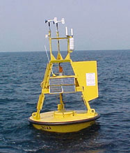
3-meter discus buoy
ARES payload

Site elevation: sea level
Watch circle radius: Approx. 100 yards
Updated Cycle: Approx. 60 Minutes

Significant Wave Height (WVHT): 2.6 ft
Swell Height (SwH): 0.7ft
Swell Period (SwP): 11.8 sec
Wind Wave Height (WWH): 2.6 ft
Wind Wave Period (WWP): 7.1 sec
Average Wave Period (APD): 5.6 sec
click here for a description of measurements

Significant Wave Height at 44017


Previous observations
TIME
(EDT)
5-day plot - Wind Direction
WDIR
 
5-day plot - Wind Speed
WSPD
kts
5-day plot - Wind Gust
GST
kts
5-day plot - Wave Height
WVHT
ft
5-day plot - Dominant Wave Period
DPD
sec
5-day plot - Average Wave Period
APD
sec
5-day plot - Mean Wave Direction
MWD
 
5-day plot - Atmospheric Pressure
PRES
in
5-day plot - Pressure Tendency
PTDY
in
5-day plot - Air Temperature
ATMP
°F
5-day plot - Water Temperature
WTMP
°F
5-day plot - Dew Point
DEWP
°F
5-day plot - Salinity
SAL
psu
5-day plot - Visibility
VIS
nmi
5-day plot - Tide (above MLLW)
TIDE
ft
2024-09-14 05:26 am--- 2.6 75.5SSE--- 68.2----
2024-09-14 04:56 am--- 2.6 75.6SSE--- 68.2----
2024-09-14 04:26 am--- 2.6 75.5SSE--- 68.2----
2024-09-14 03:56 am--- 2.6 75.5SSE--- 68.0----
2024-09-14 03:26 am--- 2.6 75.6SSE--- 68.0----
2024-09-14 02:56 am--- 2.6 85.7SSE--- 68.0----
2024-09-14 02:26 am--- 2.6 75.5SSE--- 68.2----
2024-09-14 01:56 am--- 2.6 75.7SSE--- 68.2----
2024-09-14 01:26 am--- 2.6 75.7SSE--- 68.2----
2024-09-14 12:56 am--- 2.6 75.8SSE--- 68.2----
2024-09-14 12:26 am--- 2.6 75.8SSE--- 68.0----
2024-09-13 11:56 pm--- 2.6 85.6SSE--- 68.2----
2024-09-13 11:26 pm--- 2.3 65.7SSE--- 68.4----
2024-09-13 10:56 pm--- 2.3 85.8 SE--- 68.4----
2024-09-13 10:26 pm--- 2.3 85.8SSE--- 68.7----
2024-09-13 09:56 pm--- 2.3 75.8SSE--- 68.5----
2024-09-13 09:26 pm--- 2.3 75.9SSE--- 68.7----
2024-09-13 08:56 pm--- 2.3 75.9SSE--- 68.9----
2024-09-13 08:26 pm--- 2.3 76.0SSE--- 69.6----
2024-09-13 07:56 pm--- 2.3 86.2SSE--- 69.8----
2024-09-13 07:26 pm--- 2.3 86.0SSE--- 69.8----
2024-09-13 06:56 pm--- 2.3 86.0SSE--- 69.4----
2024-09-13 06:26 pm--- 2.3 76.0SSE--- 69.1----
2024-09-13 05:56 pm--- 2.3 86.1SSE--- 70.0----
2024-09-13 05:26 pm--- 2.3 76.1SSE--- 70.0----
2024-09-13 04:56 pm--- 2.3 66.1SSE--- 70.0----
2024-09-13 04:26 pm--- 2.3 76.0SSE--- 70.5----
2024-09-13 03:56 pm--- 2.3 86.1SSE--- 71.2----
2024-09-13 03:26 pm--- 2.0 75.9SSE--- 71.2----
2024-09-13 02:56 pm--- 2.0 85.8SSE--- 71.8----
2024-09-13 02:26 pm--- 2.0 75.7SSE--- 72.0----
2024-09-13 01:56 pm--- 2.0 75.7SSE--- 72.0----
2024-09-13 01:26 pm--- 2.3 75.7SSE--- 71.1----
2024-09-13 12:56 pm--- 2.0 75.8SSE--- 70.3----
2024-09-13 12:26 pm--- 2.3 75.9SSE--- 69.6----
2024-09-13 11:56 am--- 2.0 75.6SSE--- 69.1----
2024-09-13 11:26 am--- 2.0 75.5SSE--- 69.1----
2024-09-13 10:56 am--- 2.0 85.5 SE--- 68.7----
2024-09-13 10:26 am--- 2.0 75.2SSE--- 68.2----
2024-09-13 09:56 am--- 2.0 85.4 SE--- 67.8----
2024-09-13 09:26 am--- 2.0 85.2SSE--- 67.8----
2024-09-13 08:56 am--- 2.0 85.2 SE--- 67.6----
2024-09-13 08:26 am--- 2.0 85.5 SE--- 67.1----
2024-09-13 07:56 am--- 2.0 85.3 SE--- 67.1----
2024-09-13 07:26 am--- 2.0 85.5 SE--- 67.1----
2024-09-13 06:56 am--- 2.0 85.2 SE--- 67.1----
2024-09-13 06:26 am--- 2.0 85.3 SE--- 67.1----
2024-09-13 05:56 am--- 1.6 85.5 SE--- 67.3----

Detailed Wave Summary
for 44097 as of (5:56 am EDT)
0956 GMT on 09/14/2024:

These wave data are displayed in rounded times.


Click on the graph icon in the table below to see a time series plot of the last five days of that observation.

5-day plot - Significant Wave Height Significant Wave Height (WVHT): 2.6 ft
5-day plot - Swell Height Swell Height (SwH): 0.7 ft
5-day plot - Swell Period Swell Period (SwP): 11.8 sec
5-day plot - Swell Direction Swell Direction (SwD): SE
5-day plot - Wind Wave Height Wind Wave Height (WWH): 2.6 ft
5-day plot - Wind Wave Period Wind Wave Period (WWP): 7.1 sec
5-day plot - Wind Wave Direction Wind Wave Direction (WWD):SSE
5-day plot - Wave Steepness Wave Steepness (STEEPNESS): AVERAGE
5-day plot - Average Wave Period Average Wave Period (APD): 5.6 sec
Previous observations
TIME
(EDT)
5-day plot - Wave Height
WVHT
ft
5-day plot - Swell Height
SwH
ft
5-day plot - Swell Period
SwP
sec
5-day plot - Swell Direction
SwD
 
5-day plot - Wind Wave Height
WWH
ft
5-day plot - Wind Wave Period
WWP
sec
5-day plot - Wind Wave Direction
WWD
 
5-day plot - Wave Steepness
STEEPNESS
 
5-day plot - Average Wave Period
APD
sec
2024-09-14 05:26 am 2.6 0.7 12.5 SE 2.6 6.7 SSE N/A 5.5
2024-09-14 04:56 am 2.6 0.7 10.5 SE 2.6 7.1 SSE AVERAGE 5.6
2024-09-14 04:26 am 2.6 0.3 12.5 SE 2.6 7.1 SSE N/A 5.5
2024-09-14 03:56 am 2.6 0.3 11.1 SE 2.6 7.1 SSE N/A 5.5
2024-09-14 03:26 am 2.6 0.3 11.1 SE 2.6 7.1 SSE AVERAGE 5.6
2024-09-14 02:56 am 2.6 0.3 10.5ESE 2.6 7.7 SSE AVERAGE 5.7
2024-09-14 02:26 am 2.6 0.3 11.8 SE 2.3 6.7 SSE N/A 5.5
2024-09-14 01:56 am 2.6 0.3 11.8 SE 2.6 7.1 SSE N/A 5.7
2024-09-14 01:26 am 2.6 0.3 11.8 SE 2.6 6.7 SSE N/A 5.7
2024-09-14 12:56 am 2.6 0.3 10.5 SE 2.3 7.1 SSE N/A 5.8
2024-09-14 12:26 am 2.6 0.7 11.8 SE 2.6 7.1 SSE N/A 5.8
2024-09-13 11:56 pm 2.6 0.3 12.5 SE 2.6 7.7 SSE N/A 5.6
2024-09-13 11:26 pm 2.3 0.7 10.5 SE 2.3 6.2 SSE N/A 5.7
2024-09-13 10:56 pm 2.3 0.7 11.1 SE 2.3 8.3 SE N/A 5.8
2024-09-13 10:26 pm 2.3 0.7 11.1 SE 2.3 7.7 SSE N/A 5.8
2024-09-13 09:56 pm 2.3 0.7 10.5 SE 2.3 7.1 SSE N/A 5.8
2024-09-13 09:26 pm 2.3 0.3 10.5SSE 2.3 7.1 SSE N/A 5.9
2024-09-13 08:56 pm 2.3 0.7 12.5 SE 2.3 7.1 SSE N/A 5.9
2024-09-13 08:26 pm 2.3 0.3 11.1 SE 2.3 7.1 SSE N/A 6.0
2024-09-13 07:56 pm 2.3 0.7 10.5 SE 2.3 7.7 SSE N/A 6.2
2024-09-13 07:26 pm 2.3 0.3 10.5 SE 2.3 7.7 SSE N/A 6.0
2024-09-13 06:56 pm 2.3 0.7 10.5 SE 2.3 7.7 SSE N/A 6.0
2024-09-13 06:26 pm 2.3 0.3 11.8 SE 2.0 6.7 SSE N/A 6.0
2024-09-13 05:56 pm 2.3 0.7 11.1 SE 2.3 7.7 SSE N/A 6.1
2024-09-13 05:26 pm 2.3 0.7 10.5 SE 2.3 7.1 SSE N/A 6.1
2024-09-13 04:56 pm 2.3 0.7 11.1 SE 2.3 6.2 SSE N/A 6.1
2024-09-13 04:26 pm 2.3 0.3 11.8SSE 2.0 6.7 SSE N/A 6.0
2024-09-13 03:56 pm 2.3 0.7 11.8 SE 2.3 8.3 SSE N/A 6.1
2024-09-13 03:26 pm 2.0 0.7 11.1 SE 2.0 7.1 SSE N/A 5.9
2024-09-13 02:56 pm 2.0 0.7 10.5 SE 2.0 7.7 SSE N/A 5.8
2024-09-13 02:26 pm 2.0 0.7 12.5 SE 2.0 7.1 SSE N/A 5.7
2024-09-13 01:56 pm 2.0 0.3 13.3 SE 2.0 7.1 SSE N/A 5.7
2024-09-13 01:26 pm 2.3 0.7 11.1 SE 2.0 7.1 SSE N/A 5.7
2024-09-13 12:56 pm 2.0 0.7 10.5 SE 2.0 7.1 SSE N/A 5.8
2024-09-13 12:26 pm 2.3 0.7 10.5 SE 2.3 7.1 SSE N/A 5.9
2024-09-13 11:56 am 2.0 0.3 11.8 SE 2.0 7.1 SSE N/A 5.6
2024-09-13 11:26 am 2.0 0.7 10.5 SE 2.0 7.1 SSE N/A 5.5
2024-09-13 10:56 am 2.0 0.7 11.8 SE 2.0 8.3 SE N/A 5.5
2024-09-13 10:26 am 2.0 0.7 11.8 SE 1.6 6.7 SSE N/A 5.2
2024-09-13 09:56 am 2.0 0.7 10.5 SE 2.0 8.3 SE N/A 5.4
2024-09-13 09:26 am 2.0 0.3 11.8 SE 2.0 7.7 SSE N/A 5.2
2024-09-13 08:56 am 2.0 0.7 12.5 SE 2.0 7.7 SE N/A 5.2
2024-09-13 08:26 am 2.0 0.7 11.8 SE 2.0 7.7 SE N/A 5.5
2024-09-13 07:56 am 2.0 0.3 11.8 SE 1.6 7.7 SE N/A 5.3
2024-09-13 07:26 am 2.0 0.7 11.8 SE 2.0 7.7 SE N/A 5.5
2024-09-13 06:56 am 2.0 0.3 10.5ESE 1.6 8.3 SE N/A 5.2
2024-09-13 06:26 am 2.0 0.7 11.1 SE 1.6 8.3 SE N/A 5.3
2024-09-13 05:56 am 1.6 0.7 10.5 SE 1.6 8.3 SE N/A 5.5

Description of Measurements
WVHT Significant Wave Height is the average height of the highest one-third of the waves during a 20 minute sampling period.
SWH Swell height is the vertical distance between any swell crest and the succeeding swell wave trough.
SWP Swell Period is the time (usually measured in seconds) that it takes successive swell wave crests or troughs pass a fixed point.
SWD Swell Direction is the compass direction from which the swell wave are coming from.
WWH Wind Wave Height is the vertical distance between any wind wave crest and the succeeding wind wave trough (independent of swell waves).
WWP Wind Wave Period is the time (in seconds) that it takes successive wind wave crests or troughs to pass a fixed point.
WWD Wind Wave Direction is the compass direction (degrees) from which the wind waves are coming.
Steepness Wave steepness is the ratio of wave height to wave length and is an indicator of wave stability. When wave steepness exceeds a 1/7 ratio; the wave becomes unstable and begins to break.
APD Average Wave Period is the average period (seconds) of the highest one-third of the wave observed durng a 20 minute sampling period.
MWD Mean wave direction corresponding to energy of the dominant period (DOMPD). The units are degrees from true North just like wind direction.
click here for a glossary of terms

FZUS51 KOKX 140915 CWFOKX
NATIONAL WEATHER SERVICE

COASTAL WATERS FORECAST
515 AM EDT Sat Sep 14 2024

MONTAUK POINT NEW YORK

to Sandy Hook NJ out 20 nm offshore, including Long Island Sound, the Long Island Bays, and New York Harbor ANZ350-142215- Moriches Inlet NY to Montauk Point NY out 20 nm- 515 AM EDT Sat Sep 14 2024

TODAY
NE winds around 5 kt. Seas 2 to 3 ft. Wave Detail: SE 2 ft at 7 seconds and E 1 ft at 8 seconds. Patchy fog early this morning with vsby 1 to 3 nm.

TONIGHT
E winds 5 to 10 kt. Seas around 2 ft. Wave Detail: S 2 ft at 7 seconds and E 1 ft at 9 seconds.

SUN
E winds around 10 kt. Seas 2 to 3 ft. Wave Detail: SE 3 ft at 8 seconds. Patchy fog in the morning with vsby 1 to 3 nm.

SUN NIGHT
E winds 5 to 10 kt. Seas around 3 ft. Wave Detail: SE 3 ft at 8 seconds.

MON
E winds 5 to 10 kt. Seas 3 to 4 ft, occasionally to 5 ft. Wave Detail: SE 3 ft at 8 seconds.

MON NIGHT
E winds 5 to 10 kt. Seas 3 to 4 ft, occasionally to 5 ft. Wave Detail: SE 3 ft at 8 seconds.

TUE
E winds 5 to 10 kt. Seas 3 to 5 ft, occasionally to 6 ft.

TUE NIGHT
E winds 5 to 10 kt. Seas 4 to 5 ft, occasionally to 6 ft.

WED
E winds 5 to 10 kt. Seas 5 to 6 ft, occasionally to 8 ft. Chance of showers.

WED NIGHT
E winds around 10 kt. Seas 4 to 5 ft, occasionally to 6 ft. Chance of showers.


National Oceanic and Atmospheric Administration National Weather Service
Generated at: 09/14/2024 @ 06:29AM


TERMS & CONDITIONS: Information provided on this page is intended for entertainment purposes only. By using this information you agree Sunrise Industries International shall not be held responsible for errors or inaccuracies contained herein, or any casualty, loss or damages resulting from any use of this information.


Please E-MAIL us with any questions, comments or suggestions.

montauk weather  ||  montauk tide tables  ||  montauk events  ||  montauk maps  ||  montauk pictures
home  ||  free listings  ||  our sponsors  ||  advertise here  ||  e-mail

Get Firefox


Copyright © 2010  Montauk-Online.com. All Rights Reserved.